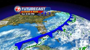
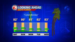
Many of you are probably working on “left-overs” from Thanksgiving feasts. In the weather, we have some left-overs as well. We’ve been seeing a fair amount of clouds lingering ahead of a cold front. The front is now steadily diving down the Florida peninsula. Most of the associated rain has been in the form of small bands, situated offshore in the Atlantic. Until the front fully crosses, we’ll run the risk of some damp weather (but not long lasting). The front is forecast to cross the south Florida mainland, and then the Keys through Sunday morning. Then, the weak boundary will simply dissipate. If you’re hoping for some cooling, this particular cold front isn’t the one for it. Winds will turn rapidly from the northeast (and then the east) so more mild nights and warm days are in the offing. The biggest change in our weather involves the healthy breeze. As high pressure strengthens to our north, look for gusty conditions to peak on Monday. Also, through the first half of the week, rip currents and bumpy boating should be expected on local waters. Another cold front will be tracked toward the end of the week, too… which is the beginning of December. Early indications are that it will be another weak one with only limited or modest cooling for south Florida.