Happy Saturday, South Florida!
Hopefully everyone had a great week! We got to enjoy a mixed bag of weather the past few days. Some days were a bit on the stormy side but there were a few days with plenty of sunshine and steamy temperatures in the mid to lower 90s. It was the feels-like temperatures that made things feel much warmer than the actual air temperature though. The workweek ended on a stormy note and that is a sign that the pattern is transitioning to an unsettled one. This morning we already saw plenty of thunderstorm activity just off of our coast line and especially across the Keys. And we’re expecting more in the forecast.

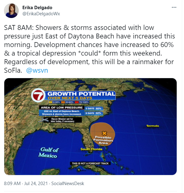
The National Hurricane Center is monitoring an area of low pressure that has developed just off of the Southeastern United States coastline. As this area meanders over the warm waters of the Atlantic (specifically over the Gulf Stream) this weekend, there will be the potential for some development with this system. A tropical depression could form this weekend but regardless of development, the forecast for South Florida will remain the same through the start of next week.
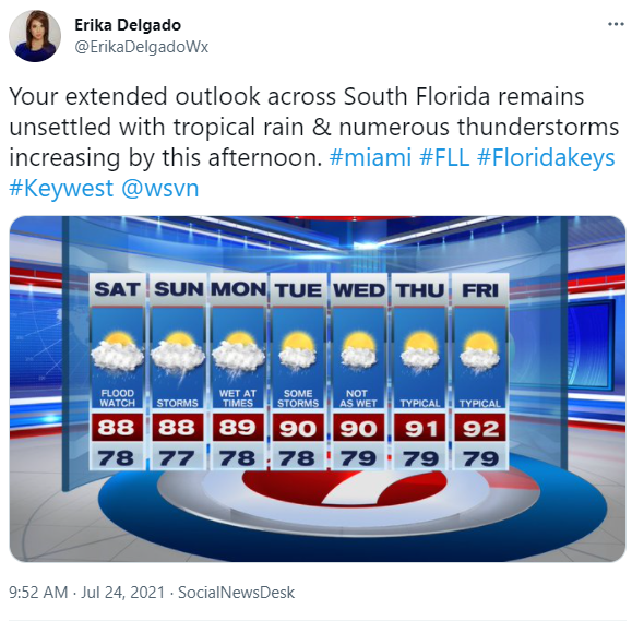
So what can we expect today? South Florida will see times of rain and during those times, the rain could be heavy on and off. So let’s call it ‘tropical rain’ increasing this afternoon with a good chance of numerous thunderstorms throughout our day. For this reason, the National Weather Service has placed coastal and metro areas of South Florida (Miami Dade, Broward and West Palm Beach) under a flood watch through at least Monday evening.

Given that a flood watch will continue through the weekend and into early next week, the forecast for South Florida the next few days is a given. Expect rounds of rain at times, scattered to numerous thunderstorms throughout the day, some of which could be strong, and mostly cloudy skies. So if you had any outdoor plans through the weekend, it might be best to move them indoors or you may run the risk of getting rained on. But if you find yourself out and about when it begins to storm… let’s not forget: when thunder roars, go indoors!

That takes us at least through the day on Monday. Tuesday will actually be quite transitional for South Florida. We will still see showers and thunderstorms in the forecast but a layer of Saharan dust finally reaches South Florida and that could lower our rain chances as we head through the middle to end of the workweek. Now that’s not to say we will see dry conditions but at least we will slowly transition to more typical rain chances. And we will finally see those typical rain chances by the end of the workweek. In the meantime, grab your rain gear and keep it with you through the weekend because we will be needing it!
Have a great weekend & keep dry!
Erika Delgado
Meteorologist
WSVN Channel 7 News
Copyright 2024 Sunbeam Television Corp. All rights reserved. This material may not be published, broadcast, rewritten or redistributed.