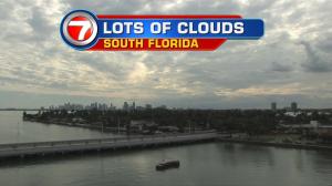
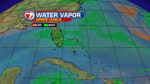
Rain has been rare recently in south Florida. That’s changing. A rise in moisture along with an approaching cold front is responsible. As a result, an unsettled sky will stick around through Tuesday. Watch for occasional rain bands and the potential for heavy downpours. The front, itself, isn’t moving rapidly. As long as it remains intact and hovering in the region, we’ll stay cloudy and damp. It’s also necessary to point out that flooding is a concern and it has nothing to do with rainfall! Instead, the strong gravitational pull from the moon (the famed supermoon) is creating extra high tides and the risk of coastal flooding. Already, there have been many instances water overspreading roads and low lying spots during times of high tide. The tidal trouble could last until the end of the week. Getting back to our current and gloomy set up, it may sound unappealing but it won’t last that long. Behind the boundary will be a steady swath of drier air. As high pressure bridges back from the north, we’ll see steady clearing. Remember that drier air has a tendency (and ability) to “cool off” more effectively. In this case, cooling support is limited but we’ll see a minor decline. Milder air will shift into south Florida and keep us both comfortable and seasonal. Toward the end of the week, winds will turn back off the ocean and humidity values will attempt to rise. Having said that, another cold front looks to squash that change from dominating. A secondary front is slated to reach us this upcoming weekend. It won’t have as much moisture to work with (as compared to its predecessor) but should have more cooling potential. While it’s still quite early to take stock in long range temperature forecasts, it’s possible that the weekend cold front could bring down the coolest air of the season, thus far. Stay tuned.