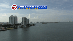
Rain and storms have been the rule, lately. The soggy times are a recent trend after a dry start to the south Florida Rainy Season back in mid-May. With the higher frequency of rain, sunshine has been at a premium. Here’s a welcome brighter type of sky (from late Monday) along Biscayne Bay.
On Monday, the majority of rain and storms arrived during the morning and it was a reversal of the pattern favoring afternoon activity. Notice here, we find a big variety of rain amounts across the area.
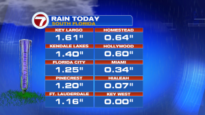
Where have we found the most storms, recently? Ft. Lauderdale chalked up over one-half foot of rain just since last Friday!

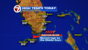
Despite the wet weather, most places haven’t had difficulty reaching seasonal high temperatures. The “hot spot” stand-out, again, includes the Middle Florida Keys. On Monday, Marathon soared to 96-degrees, a new record high for the date. Even more impressive is that Marathon has had record highs for 8 out of the past 10 days (since June began)!
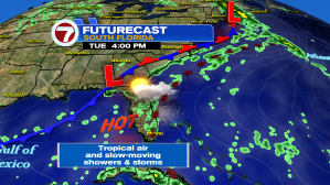
On the weather map is a stretched-out front that’s to our north. The boundary won’t move much over the next few days. That means more local winds coming mainly out of the steamy south. Tropical air will likely trigger times of rain with occasional storms. The set up may finally budge into next weekend with winds turning off the Atlantic.