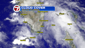
On the heels of a big Sunday soaking, we’ll likely see more rain moving our way on Monday. Here’s how we were socked-in (Sunday) with deep and persistent clouds. Because of the lack of sunshine, temperatures struggled to reach typical warming levels over much of south Florida. Miami briefly touched 83-degrees at daybreak, followed by steady readings in the 70’s thereafter!
Upon glancing at rain amounts, from Sunday alone, you can see it was impressively wet. Miami was just shy of a record rainfall for the date and took “top prize” in rain accumulation. It was also the wettest day of the year, so far, for the Magic City!

Monday’s weather pattern includes more streaming moisture over us. Additionally, an upper disturbance will provide the energy to spark more rounds of rain with storms.

Here’s a look at a forecast model for mid-day Monday. It shows heavy pockets of rain filling-in from the south and west. Rain bands will tend to drift over to the Atlantic coastal areas. Since we’ve had so much rain over recent days, the threat of flooding is a serious hazard.
