Happy Saturday, South Florida!
Hopefully everyone had a great work week despite the torrential downpours we saw Thursday and Friday. The week started off nice but then tropical moisture from the Caribbean spread across South Florida while a weak front across northern sections of our state trapped the moisture over our area. This left for a few soggy days here in South Florida. This morning we woke up to breezy conditions with plenty of shower activity already over the Atlantic waters. Showers expected to affect our area once again.
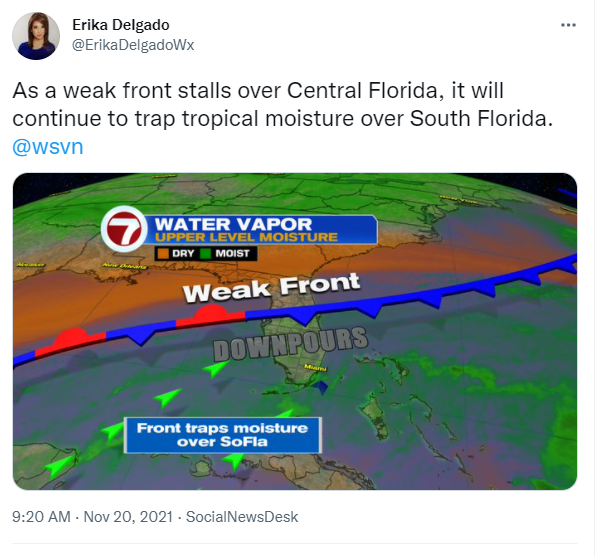
Currently there is still plenty of available moisture over South Florida while a weak front continues to drop south across our state. This front continues to trap moisture over South Florida which will help keep shower activity present. Unfortunately this front will bring no temperature change across South Florida.
Be sure to grab that rain gear today because South Florida can expect on and off showers once again. With a stronger East to Northeast breeze and with plenty of shower activity offshore, our wind pattern will continue to tap into that moisture and bring showers our way from time to time. Expect mostly cloudy skies once again while we continue to see breezy to gusty conditions throughout the day. Afternoon high temperatures will once again reach the lower 80s, which happens to be average for this time of year.

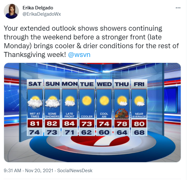
As of this writing, the latter part of the weekend will continue to bring on & off showers across South Florida. Unfortunately, there will still be plenty of moisture nearby and with a front fizzling out over our area, showers will once again be possible throughout the day. They may just not be as widespread as we have been seen recently.

Looking ahead, all eyes will turn to a much stronger front that will be entering our state by Monday morning. Unlike this weekend’s front (which brings lots of moisture and no temperature change), this second front will bring some welcomed changes. There will be limited moisture with it but of course we do live in South Florida so a shower or two cannot be ruled out as the front gets closer. Behind the front, cooler and drier air will finally begin to filter into our area as early as Tuesday morning. Temperatures Tuesday will start off in the lower 60s and will struggle to even hit the mid 70s during the afternoon hours. The rest of the holiday week looks picture perfect across South Florida as we continue to enjoy low humidity, low rain chances and comfortable temperatures through the Thanksgiving holiday.
Have a great weekend!
Erika Delgado – Meteorologist
WSVN Channel 7 News
Copyright 2024 Sunbeam Television Corp. All rights reserved. This material may not be published, broadcast, rewritten or redistributed.