Happy Friday, South Florida!
Two weeks into the rainy season and it seems someone turned off the faucet the moment it began! South Florida has remained almost completely dry since then. And earlier this afternoon was no different as we saw plenty of sun.

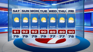
While rain is desperately needed across some spots, it seems this mostly dry weather pattern will continue for at least another night. But as all things eventually come to an end, showers will slowly return to the forecast And it looks like it will return as early as this weekend. (about time right?)
Tonight in South Florida will remain quiet. But although it will seem like there is no change going into tonight and tomorrow, South Florida is already undergoing a change as far as conditions are concerned. The high pressure system over the Atlantic has begun to break down and is pushing farther into the Atlantic. As a result, winds have already begun to veer out of the Southeast AND wind speeds have decreased since earlier this week. This has allowed temperatures to warm up while allowing humidity to slowly creep back into the forecast. As we head into the weekend, winds will veer a bit more out of the South, which will help temperatures warm even more AND will allow moisture to creep back into the forecast in the days to come.


Isolated showers return to the forecast tonight and early Saturday. Saturday’s afternoon high temperatures will be warmer than the last few days, hovering at about or just above 90 degrees. Of course, with more humidity in place, temperatures will begin to feel much warmer than the actual temperature. It is finally beginning to feel like Summertime in South Florida (which by the way the start of Meteorological Summer officially begins this weekend).


As the weekend progresses, more moisture moves back into the forecast. So while isolated showers are possible for the start of the weekend, South Florida could see a few isolated afternoon thunderstorms developing by the end of the weekend and for the start of the upcoming work week. With some dry air still in place in the mid and upper levels of the atmosphere, some of the storms could be on the stronger side Sunday afternoon.


As showers slowly return to the forecast, a warming trend will officially be underway through the weekend and with higher humidity in place, heat index values across some spots could easily soar into the 100s! So let’s remember to keep hydrated in the days to come because afternoons in South Florida are about to become less comfortable!

And of course let’s not forget that hurricane season officially begins this weekend and as we have seen in the past, we don’t officially need to be in the season for tropical systems to form (As we saw with Subtropical Storm Andrea earlier this month!). With that said…we are currently watching a broad area of low pressure near the Yucatan Peninsula for tropical development. As this system drifts Westward in the days to come, gradual development is possible especially once it moves over the warm waters of the Gulf of Mexico. Regardless of development, heavy rainfall is expected for much of Southern and Coastal Mexico. Luckily for us, this system will have no direct impact on South Florida.


Have a great weekend!
Erika Delgado
Weekend Meteorologist
WSVN Channel 7 News
Copyright 2024 Sunbeam Television Corp. All rights reserved. This material may not be published, broadcast, rewritten or redistributed.