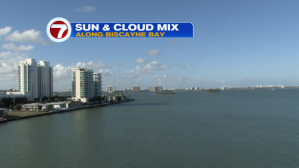
We’re “on a roll” with plenty of warmth holding tight. The pattern began way back at the start of February. At that point, cold fronts abruptly stopped crossing south Florida. The reason? Strengthening high pressure started taking over, and it hasn’t budged since! The persistence will continue through the rest of the week, too, with no definitive end in sight. That means warm and breezy conditions will be the rule. Here’s a look at the beautiful sky from Wednesday afternoon (along with official highs at the main south Florida reporting stations).

The most tranquil weather across the nation can be found “here at home”. Florida is void of the virtual parade of storms tracking across the country every few days. The latest storm system is bringing a large area of rain and snow (and some ice in between)! Unsettled conditions impact most of the northeast and Middle Atlantic states.
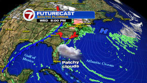
Heading into Thursday, nearly identical weather is on the way for our region. Look for only spotty showers while unseasonable warmth hangs on.

Notice on the following map (which includes the jet stream) that a similar set up is likely to hold for the remainder of the week. The jet is drawing up a lot of warm and moist air that’s heading along the storm path, north of Florida. For us, it’s high pressure that sticks around. It’s going to keep us mainly dry and steadily warm into the weekend and beyond.
