Happy Sunday, South Florida!
Hopefully everyone had a wonderful holiday weekend.
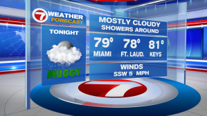
Unfortunately it wasn’t the sunniest nor was it the driest one at that!
So why such an ugly weekend? Well we can thank the position of the high pressure currently over the Atlantic. That has allowed winds to veer out of the South and Southwest. In turn, this helped pump in tropical moisture across much of our Sunshine State, especially across South Florida. So while temperatures were much warmer at the end of last work week, the cloud cover, the ocean breeze and the showers & storms this weekend helped keep temperatures to near seasonal. Unfortunately, though, after a rather wet and cloudy weekend, it looks like South Florida is in store for a soggy start to the upcoming work week.


Deeper tropical moisture is expected to move into South Florida for the start of the upcoming work week. Increased cloud cover & a much higher rain and storm chance will overtake the forecast, which means temperatures will struggle to reach the 90-degree mark through the first half of the work week. Good news is that as that tropical moisture begins to move away, South Florida will finally see a bit MORE in the way of sunshine and LESS in the way of rain & storms. That will have a direct impact on our afternoon temperatures for the next upcoming weekend.


So what about the days leading up to the next weekend? As much as I would love to say we are certain that the tropical moisture will move on after a few days, the truth is that there is still lots of uncertainty regarding next week’s forecast. For this reason we need to take a trip to the Heartland of the Country. That’ right, I said the Nation’s Heartland!!


A disturbance riding along a cold front (currently near the Tennessee Valley) will slowly drift South and eventually stall out somewhere over Northern Florida. As the disturbance drops into the Northern Gulf of Mexico, we will be keeping a close eye on the potential for a low pressure system to develop along that front somewhere over the Northeastern Gulf. And of course given the time of year & the warmth of the surrounding Gulf waters, any disturbance that were to develop there could easily gain tropical characteristics. That will be something we will need to keep a close eye on.


But regardless of the formation of any system (tropical or not), the wind flow during that time will allow for more tropical moisture to push through all of Florida. What does remain uncertain is how much rain is expected for South Florida so we will continue to monitor the situation and keep a close eye on the Tropics in the days to come. In the meantime, let’s focus on the soggy setup that South Florida is about to experience through the first half of the work week.
Have a great week & remember to keep that rain gear close!
Erika Delgado
Weekend Meteorologist
WSVN Channel 7 News
Copyright 2024 Sunbeam Television Corp. All rights reserved. This material may not be published, broadcast, rewritten or redistributed.