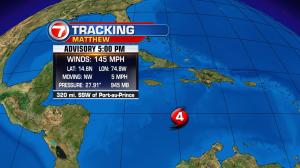
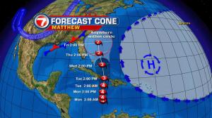
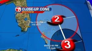
Matthew is still a major hurricane in the Caribbean. The large and sluggish system is creeping northward (generally) and poses several serious threats to Jamaica, Haiti, and Cuba over the next two days. Gradually, then, the hurricane will expand to include nasty weather conditions into the Bahamas. There are several concerns for the islands early this week. They include the threat for extremely heavy and persistent rainfall, flash flooding and mudslides. If Matthew remains a slow-mover, a significant section of Haiti could pick up between 30 and 40 inches of rain by the middle of this week, alone! The forecast track hasn’t changed much over the past several advisories. Models are also showing better confidence in the idea that Matthew will lift over eastern Cuba in the Tuesday time frame. After that, there’s consensus of the hurricane impacting most (if not all) the Bahamian islands. As it stands now, south Florida is “out of the cone of concern” but that doesn’t mean that some hazards can’t still materialize. There’s a decent chance that some fringe activity could make for unsettled weather during the middle of the work week. That could include some outer rain bands, gusty winds (especially near the coast) and higher surf. It’s also important to note that even a slight veer in the track, closer to Florida, could ramp up those concerns and more. Continue to follow the progress of Matthew over the next few days. Some minor weakening is expected, but it’s still capable of producing rough weather extending out of this very large hurricane.