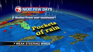
South Florida rain has been “on and off” like a water faucet. The occasionally heavy downpours will form (often in conjunction with the heating of the day) then drift around in batches. Since steering winds remain weak, some of the rain will seemingly hover. Accumulations could be significant (at least for run off, along roads) and lead to localized street flooding. On Tuesday afternoon, this scenario played out and a flood threat extended all the way from Miami International Airport southward to Homestead and Florida City. With just a couple days left in June, we’re rounding out the month with the likelihood of rain and afternoon storms. First, there’s plenty of tropical moisture over the region. Next, small and developing disturbances will easily trigger wet weather. The daily sea breezes combined with an Atlantic low pressure area that’s “high in the sky” (an upper low) will be contributors to unsettled conditions. For now, we’re expecting active afternoons at least through the end of the work week. Looking ahead to the holiday weekend, then, the local weather pattern will feature near normal rain and storm chances. Scattered downpours will hold in the forecast, but the general trend will be for most storms to fizzle before nighttime fireworks displays.