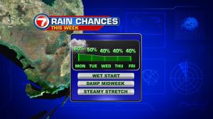
Several features are coming together to bring back rain to south Florida during the early part of this week. Sporadic showers and occasional storms will be “at work” during the Labor Day holiday. It’s largely the result of expanding moisture from both the north and east. Light winds won’t be helpful since it will mean slower moving activity. Of course, be prepared for heavy downpours that may have you seeking cover from time to time. The strongest activity is likely to happen with the heating of the day and as sea breeze circulations get more active. This unsettled pattern, by the way, should hold through Tuesday. Then, high pressure will slowly build back into the region curbing at least some of the activity. In the tropics, distant Hermine is taking a slow turn over the western Atlantic Ocean (well offshore from the northeastern states). Still, due to the sprawling size of the system, it’s still a big wind-maker creating a lot of trouble along the southern New England coastline.