Happy Saturday, South Florida!
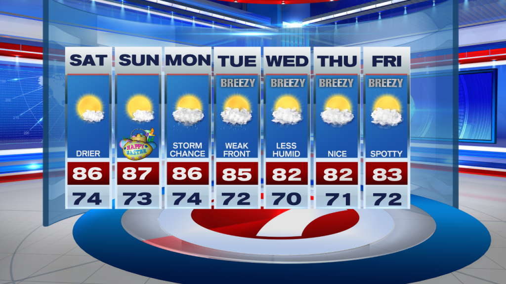
The weekend is finally here and it promises to bring some improvements to the forecast. After ending the week on a stormy note, this morning South Florida woke up to quiet conditions with only an isolated showers or 2. Temperatures remained on the warmer side in the mid to lower 70s. Unfortunately the humidity is still on the higher end but at least the weather pattern is beginning to change and we will notice the difference as the day goes on.
Slightly drier air has moved into our area today. With a Southeast breeze, any shower or thunderstorm activity in the afternoon will be focused across interior sections of South Florida or out across the west coast. That means that other than an isolated shower or two, South Florida looks to remain mainly dry with warm temperatures back into the mid 80s. This is exactly what we like to see for the weekend! Great news is that the forecast should remain just as nice (with low rain chances) for the latter part of the weekend!

However, all good things do come to an end and it looks like our ‘end’ will begin on Monday. Moisture will increase across our area ahead of our next Front (yes, another mid-April Front) and this will increase our rain and storm chances throughout the day on Monday. The front looks to push through South Florida on Tuesday and even though we are not expecting significant cooling with this front, we will feel the difference by the second half of the work week where humidity levels begin to drop a bit. Our afternoon high temperatures during this time will be in the lower 80s so it will actually bring some relief this time around.
Have a wonderful holiday weekend!
Erika Delgado
Meteorologist
WSVN Channel 7 News
Copyright 2024 Sunbeam Television Corp. All rights reserved. This material may not be published, broadcast, rewritten or redistributed.