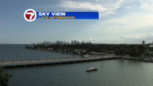
After such a mild start to the week, we’re feeling a change in the air. On Thursday, local temperatures were easily rising into the mid 80’s. The warmth was being delivered by a steady southeast wind (and plenty of sunshine helped out, too). Here’s the Miami view from late in the afternoon with mainly high cirrus clouds over the city and beyond.
The stage is set for the hottest period of the week, coming Friday afternoon. At that time, southerly air will have most of southeast Florida with temperatures resembling summertime. Highs will approach 90-degrees ahead of a weakening front from the Gulf.
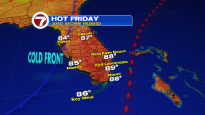
The weather map on Friday shows how we’ll be “caught” between distant high pressure (east of the Bahamas) and the aforementioned cold front, to the west.

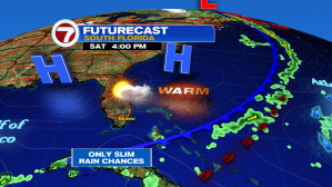
The latest available data, with weather forecast maps, indicates the front will push into drier air from late Friday through Saturday. That will likely keep showers and potential storms at a minimum (very isolated).
After a quiet weekend of weather with high pressure sitting north of us, we’re expecting another breezy stretch to begin Monday afternoon. At that time, some additional moisture may get transported into our region from the south and east. Showers will likely be short-lived, since they’ll move swiftly, but periods of “in and out rain” will be possible.
