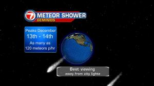
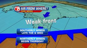
Our temperatures are ready to rise. After “cooler than normal” days due to frequent clouds and rain, we’ll be treated to December warmth very soon! What’s even more impressive is that record highs will be within reach, especially on Wednesday! The change is due to a switch in winds. The speeds aren’t too strong but it’s the wind direction that’s important when it comes to how it feels outdoors. As the air turns more out of the south from Tuesday through Wedneday, we’ll get the growing warmth. Keep in mind that our average high is around 78 degrees. Instead of highs in the 70’s, we should reach into the middle 80’s. Even before watching the thermometers, there’s something more exciting to see. On Tuesday there’s actually 2 things to view, if sky conditions cooperate. First, there’s the “supermoon” (third and final one this year). This full moon will appear bigger than brighter than normal. Then, there’s the hope of seeing the Geminid Meteor showers. The annual shooting stars began back on December 4th (and will last through the 17th) but peak this Tuesday night into Wednesday morning. The challenges will be threefold: clouds, city lights, and the brightness of the supermoon all may lend to poor viewing of the meteor showers. The upcoming weather pattern includes a few interesting features as well. There’s an approaching cold front on Thursday. As mentioned before, the biggest surge of warmth will arrive ahead of the front. Behind the boundary, then, it ‘s not going to be much cooler. The end of the week will be breezy and comfortable with near seasonal temperatures. By the way, minor coastal flooding is possible, but not because of rainfall. Tides will be higher than normal due to the extra gravitational pull (courtesy of the supermoon).