Our south Florida weather has been highlighted by heat, lately. On Saturday, Miami reached 89-degrees (average high is 86) with lingering high humidity. Then, on Sunday, hazy sunshine combined with light winds out of the tropics to send temperatures up to 91-degrees! That was a record high for the date, in Miami. Also, Key West tied the record in the Lower Keys, matching 89-degrees.


As the day progressed, clouds were increasing with the advance of a weakening cold front. What’s notable about this front is that it’s the first one to cross south Florida this fall season, even if its impacts aren’t a big deal (they’re not). It’s simply not the kind of cold front that’s able to deliver much of a cooling difference “this far south”. Notice the difference in degrees, though, forecast for the northern third of the state. Basically, north of I-4 (Orlando vicinity) many spots are set to feel the 50’s on Monday morning. What about south Florida? We won’t detect much of a temperature difference since the boundary only was able to limp by. However, you’ll feel lower humidity levels. Winds are increasing out of the northeast and a breezy set up is also in store.

The cold front has basically gotten as far south as it’s going to go. It’s a classic case of a frontal “hang up” as the boundary stalls nearby. It may even lift back north (beyond Monday) which might trigger more areas of rain. As it stands now, batches of showers will occasionally push off the ocean and into favored areas of south Florida to start the week.

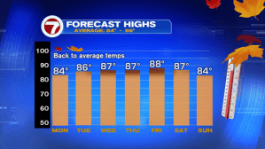
Looking ahead, temperatures will tend to get warmer as the week continues, although not as hot as recent days.
What’s interesting about the late week time frame is that ANOTHER cold front is slated to move our way. Ahead of it, daily doses of rain will be possible through Friday. If the next front can punch southward far enough, the start to next weekend could bring drier and possibly cooler weather. For now, the long range models aren’t too aggressive. It is, though, a telling sign that we’re now in the time of the year when cold fronts are arriving and crossing. Eventually, they’ll come down more frequently with more forceful episodes of cooling.