Happy first Sunday of 2022, South Florida!
Hopefully everyone was able to spend the holidays safe and healthy surrounded by loved ones. We were quite lucky this past weekend as we saw quiet conditions (although it was a bit on the warm side). Humidity levels were not TOO high so at least we didn’t have to worry about those extra muggy evenings that we have experienced before. But now that we are in the start of January many of us are left wondering when we will see temperatures a bit more typical for this time of year. Well I’m happy to report that some changes are headed our way.
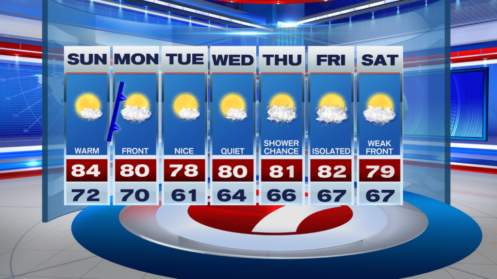
If you are planning on continuing your New Year’s festivities today, then you won’t need to worry about weather ruining your plans. While our afternoon temperatures will once again reach into the mid 80s, rain remains out of the forecast once again. So if your Sunday plans take you out to the beach, then you should be good to go. However wind speeds will begin to pick up later this afternoon so it is possible that we could see an elevated risk of rip current across our beaches. Stronger wind speeds will also impact our marine conditions. So let’s use plenty of caution if spending any time near or on the water today. Apart from that, a warm winter day in South Florida is what you can expect.

Looking ahead though we do see some changes to the forecast. For one, a front will push through South Florida on Monday, which will finally bring an end to these warm conditions once again (albeit a short-lived one). A spotty shower or two will be possible on Monday as the front swings through our area. Temperatures on Monday won’t be AS warm during the afternoon however we can still expect high temperatures to be reaching into the lower 80s. Tuesday is when we finally see slightly cooler conditions with most of South Florida waking up in the lower 60s and a few areas dropping into the upper 50s. Tuesday’s high temperatures will remain in the 70s (which is typical for us this time of year). The rest of the work week looks quiet while the gradual warming trend takes shape through the remainder of the forecast period. A few showers could return to the forecast by the end of the work week.
Have a wonderful weekend!
Erika Delgado
Meteorologist
WSVN Channel 7 News
Copyright 2024 Sunbeam Television Corp. All rights reserved. This material may not be published, broadcast, rewritten or redistributed.