Happy Sunday, South Florida!
The 2019 Atlantic Hurricane Season officially began yesterday and as we have seen in the past, we don’t officially need to be in the middle of the season for tropical systems to form (as we saw with Subtropical Storm Andrea during the month of May). We continue to watch a disorganized area of low pressure in the Southern Bay of Campeche for tropical development. As this system drifts Northwestward towards the coast of Mexico, gradual development into a tropical cyclone is possible in the next few days. Regardless of development, heavy rainfall is expected for much of Eastern Mexico. Luckily for us, this system will have no direct impact on South Florida.

Meanwhile closer to home, rain is desperately needed across some spots. While a few South Florida spots saw showers & thunderstorms yesterday, Saturday was not a washout by any means. And, similar to yesterday, showers will once again return to the forecast today with the focal point for thunderstorms remaining across inland areas.

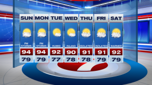
The high pressure system over the Atlantic that kept conditions quiet for us for almost 2 weeks has begun to break down and has pushed farther into the Atlantic. As a result, winds veered out of the South and Southwest while wind speeds have decreased since last week. This allowed Saturday’s afternoon temperatures to tie records while allowing humidity to slowly creep back into the forecast. Today afternoon high temperatures will once again flirt with near-record high’s as they soar well into the mid 90s.


As we are all too familiar with here in South Florida, steamy temperatures are usually accompanied with high humidity. This means that afternoon temperatures today will feel much warmer than the actual temperature. Heat index values will soar into the upper 90s while in some spots will actually feel like the 100s! It is finally beginning to feel like Summertime in South Florida (which by the way the start of Meteorological Summer officially began yesterday).


Chance for isolated afternoon showers and thunderstorms continues for the start of the upcoming work week. With some dry air still in place in the mid and upper levels of the atmosphere, some of the storms could be on the stronger side today and Monday afternoon. So while typical rain chances make their way back into the forecast, temperatures will remain on the steamy side. So let’s remember to keep hydrated in the days to come because afternoons in South Florida are about to become less comfortable!


Have a great weekend!
Erika Delgado
Weekend Meteorologist
WSVN Channel 7 News
Copyright 2024 Sunbeam Television Corp. All rights reserved. This material may not be published, broadcast, rewritten or redistributed.
