It’s a seasonally warm start to April across south Florida. Monday’s highs were in the lower to middle 80’s with winds turning out of the south. As you’d expect, a southerly flow was bringing more tropical humidity into the region.

High clouds have been advancing from the west while thicker clouds and rain extend across parts of central and north Florida.

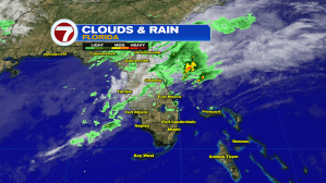
As Tuesday begins, a frontal boundary (stalled) is straddled across the middle of the state. By Tuesday afternoon, however, it punches south as a cold front. Be aware that scattered downpours are possible including isolated storms. Since the front is expected to arrive during the afternoon, it will meet up with prime daytime heating. We don’t expect widespread rain (and many places will remain dry on Tuesday) but favored spots could get a round or two of rough weather, prior to sunset.

Behind the cold front we’ll see temperatures fall a few degrees (maybe up to 5). While it won’t be a lot of cooling, it will feel more comfortable due to lower humidity levels. Also on Wednesday, we’ll get a developing breeze off the ocean. Later in the day there’s a chance for a few brief showers (along that breeze).

As for rain chances in the days ahead, they won’t stray too far from average. Each day will involve at least a “chance encounter” with a passing rain shower.
