Fall began weeks ago but it seems it never even came close to arriving to South Florida. Until this weekend. Finally, a cold front that we had been watching since the start of the week crossed through South Florida on Saturday morning. And while Saturday afternoon was still a steamy one, the cooler and drier air finally reached us overnight into Sunday morning. And boy was it worth the wait! The temperature change was definitely felt across all of South Florida on Sunday morning:

The good news is that a light Northeast breeze will help temperatures cool well into the 50s and 60s again by Monday morning.

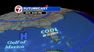
High pressure over the Gulf of Mexico will leave that Northeast breeze in place for a few days so expect comfortably cool conditions each morning and pleasantly sunny afternoons through the middle of the work week.
By Monday evening into Tuesday, another dry cold front will swing through our Sunshine State, bringing a reinforcing shot of cool air across all of Florida. While temperatures won’t drop too much, we can still expect them to be at or just below the norm for this time of year.


All will remain quiet until the high pressure system begins to break down, allowing for moisture to slowly creep back into the forecast. We can begin to see this change by the end of the work week where rain chances are expected to spike up and linger for a few days.

So let’s enjoy these comfortably cool and pleasantly dry days before the rain returns. Have a great week!
Copyright 2024 Sunbeam Television Corp. All rights reserved. This material may not be published, broadcast, rewritten or redistributed.