Happy Saturday, South Florida!
Hopefully everyone had a wonderful Fourth of July holiday. Our Saturday began a bit differently across South Florida. We woke up to mostly cloudy skies, anytime showers & temperatures in the mid to low 80s.

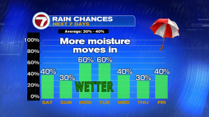
With high pressure over the Atlantic, winds have veered out of the Southeast, which has helped pump in tropical moisture across South Florida. So while temperatures started off much warmer than average, the cloud cover, the ocean breeze and the showers & storms expected in the forecast today will help keep temperatures to near seasonal later this afternoon. And while the weekend looks to have started a slightly wetter foot, things should go back to normal for the latter part of the weekend with only an isolated shower and storm chance on Sunday.


However, the drier weather will be short-lived this time around. Deeper tropical moisture is expected to move into South Florida for the start of the upcoming work week. Increased cloud cover & a much higher rain and storm chance will overtake the forecast, which means temperatures will struggle to reach the 90-degree mark through the first half of the work week. Good news is that as that tropical moisture begins to move away, South Florida will finally see a bit MORE in the way of sunshine, LESS in the way of rain & storms and that will have a direct impact on our afternoon temperatures. The second half of the upcoming work week is looking drier and much warmer with afternoon high temperatures easily reaching the mid 90s!


Lots of uncertainty regarding next week’s forecast. For this reason we need to take a trip to the Heartland of the Country. That’ right, I said the Nation’s Heartland.
A cold front slowly drifting South will eventually stall out somewhere over Florida. We will be keeping a close eye on the potential for a low pressure system to develop along that front somewhere over the Gulf of Mexico. And of course given the time of year & the warmth of the surrounding Gulf waters, any disturbance that were to develop there could easily gain tropical characteristics. Regardless of the formation of any system, the wind flow during that time will allow for more tropical moisture to push through all of Florida. What does remain uncertain is how much rain is expected for South Florida so we will continue to monitor the situation and keep a close eye on the Tropics in the days to come.


Have a great Saturday & watch out for RIP CURRENTS along Atlantic beaches today.
Erika Delgado
Weekend Meteorologist
WSVN Channel 7 News
Copyright 2024 Sunbeam Television Corp. All rights reserved. This material may not be published, broadcast, rewritten or redistributed.