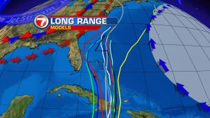
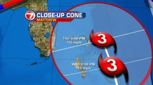
Hurricane Matthew is still very far from south Florida (over 900 miles away, as of Saturday evening). That gives us plenty of time to monitor its track as we head into the new week. On Saturday, Matthew exhibited some “eye opening” strength with sustained winds at 150 mph (category 4 levels) over the central Caribbean Sea. This healthy system doesn’t have much to weaken it, and it’s still quite far from the nearest islands with soonest risk: Jamaica, Haiti, then eastern Cuba. The most distinctive difference we’re seeing now, though, is a movement trend toward the north or northwest. That track is what’s forecast by the National Hurricane Center over the next few days. This overall motion is very important when it comes to the future of Matthew. If the hurricane can complete a fairly sharp turn, the eventual focus will be for it to move toward the central Bahamas (and possibly farther away from Florida). However, a more gradual turn would make it increasingly dangerous for south Florida by the middle of the week. It’s worth noting that Hurricane Matthew is a large-sized system. Even if it “turns on a dime” many fringe, or indirect impacts could come into play, locally. Higher winds, higher seas, more numerous rain bands could all be issues we face… by Wednesday and Thursday. For now, we must simply watch from afar and think about hurricane preparation plans, should they become necessary. Make sure you check your supply list (water, batteries, etc) in case the Hurricane Center includes our local areas under future advisories. We, on Channel 7, will help keep you updated with all of the information that’s important to know.