There’s a good reason why we call them “cold snaps” (they simply don’t last very long)! The most recent batch of colder air arrived behind a cold front on Wednesday. Already, there’s an end in sight, and it’s not far away.

Here’s a look at the forecast lows (when you wake up Friday morning) for Broward County, Miami-Dade and the Florida Keys. We’re mostly looking at the lower to middle 50’s, with some lower 60’s in portions of the Keys.


The next set of weather changes will come as high pressure shifts off the northeast coast of the United States. The distant high will have impacts all the way into Florida as our winds turn. Remember, of course, it’s a clockwise wind flow around high pressure. The ocean air will allow local temperatures to trend warmer into the weekend.
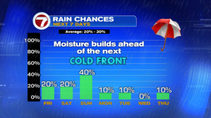
With the onshore pattern in place (late week through the weekend) we’ll see an uptick in moisture. Rain chances will creep higher for the days ahead. On Friday, any rain bands off the Atlantic won’t last long due to a healthy breeze pushing them along. Then, on Sunday, rain chances actually peak ahead of the next cold front. The boundary is likely to push through all of Florida Monday morning with drier and cooler conditions returning.