Happy Sunday, South Florida!
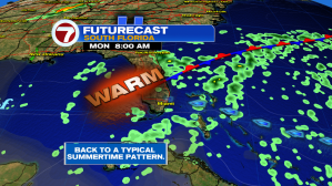
We have been slowly transitioning back to normal this weekend. After a beautiful (but warm!) start to our morning, it looks like business is back to normal by this afternoon.


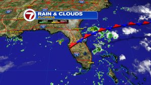
While a high pressure system over the Atlantic strengthens through the weekend, a weak stationary front over Northern Florida is slowly washing out. While rain and storm chances remain hit or miss today, a few of those storms will try to inch their way towards East Coast metro areas. So if you have any outdoor plans late afternoon or early evening near inland areas, be sure to keep the umbrellas with you just in case.


And it looks like this typical pattern continues through much of the upcoming work week. Passing coastal morning showers will give way to a few sea breeze afternoon thunderstorms, eventually pushing towards Interior areas.


And speaking of tropical moisture, a lot of dry air & Saharan dust over the Atlantic have helped keep tropical waves over the open waters in check. However a tropical wave currently over the Lesser Antilles could eventually make its way towards South Florida, increasing rain chances by the end of the upcoming week.


Enjoy what’s left of your weekend & keep hydrated!
Erika Delgado
Meteorologist
WSVN Channel 7 News
Copyright 2024 Sunbeam Television Corp. All rights reserved. This material may not be published, broadcast, rewritten or redistributed.