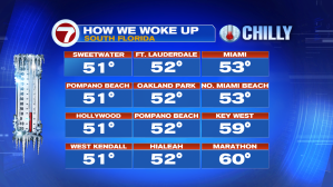
The latest cold wave has ended, peaking Thursday into Friday. Here’s how we woke up on Friday morning.
Even though we started the day with clear skies and a chill (Friday) by the afternoon milder air was working back in. Why the change? The general wind direction took a turn. Instead of winds from the north, our air flow began veering from the east. That’s a warmer-feeling set up, from the Atlantic.

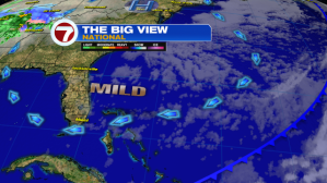
We’re still under the dominance of high pressure that’s centered over the northeastern states. To the distant west, another weather system is brewing.

The heart of that storm will lift north this weekend. In its wake, large areas of rain will transition to snow and ice. Numerous winter advisories currently extend from the middle of the nation to the eastern seaboard for this weekend.

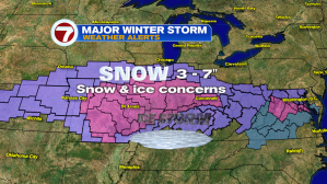
Even though the real storm energy will be far removed from Florida, a trailing cold front will shift into the area from west to east. Ahead of the front we could see a few rain showers (20-30% chances over the weekend). Once the cold front passes, drier air will return. Then, another burst of colder air will filter down the peninsula. Expect another “cold snap” from Monday through Wednesday of next week.
