Happy Sunday, South Florida.
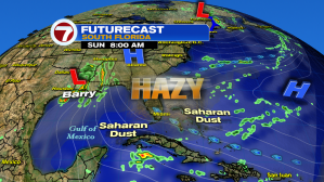
While we woke up to mostly quiet conditions, skies across South Florida were on the hazy side because of the layer of Saharan dust that extends from the Atlantic across the Bahamas & the southern half of our peninsula. That means our South Florida sky will actually look milky blue rather than the bright blue we like to see.


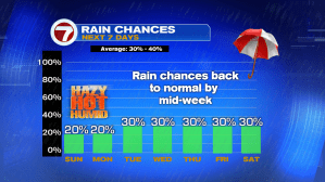
High pressure across the Atlantic, drier air in the upper levels of the atmosphere and a layer of Saharan dust will all help keep rain chances across South Florida & Bahamas on the lower side today. And of course with an ocean breeze in place, temperatures will remain near seasonal this afternoon, not to mention that any shower or storm activity that DOES develop will push inland towards Interior areas & the Gulf Coast.


Good news is that this drier weather pattern is here to stay through the start of the work week. So feel free to plan any outdoor activities today as rain won’t be a major issue through Monday. And while temperatures this weekend have remained warm & seasonal, the high humidity levels across South Florida will make temperatures feel like the 100s. So please be sure to keep hydrated if spending any significant time outdoors today.


Shifting focus towards the Tropics. We have been keeping a close eye on Barry pushing farther inland across Western Louisiana. Barry weakened into a tropical storm shortly after making landfall Saturday afternoon but continues to be a slow-moving storm dumping heavy rainfall across Louisiana, Mississippi, Alabama & even Arkansas! As a result, flood watches and warnings are still in effect for many living across the Gulf Coast states. Good news is that Barry is expected to weaken even more by this afternoon, possibly becoming a remnant low pressure at that time.


And while we’re still on the subject of “Tropics”, the tropical wave over the Central Atlantic that the National Hurricane Center was keeping an eye on yesterday has since fizzled out due to battling lots of dry air ahead of it.

Lastly, as temperatures will be warm enough and conditions will be dry enough….If heading out to the beach today, please watch out for rip currents along East Coast beaches.
Enjoy your Sunday Funday!
Erika Delgado
Meteorologist
WSVN Channel 7 News
Copyright 2024 Sunbeam Television Corp. All rights reserved. This material may not be published, broadcast, rewritten or redistributed.