It doesn’t get much better than this! South Florida continues a stint of nice and dry weather with seasonal temperatures. Only limited clouds can be found over the region. Here’s a beautiful view of Biscayne Bay from Tuesday afternoon.

An expansive area of high pressure is keeping our weather quiet, well beyond Florida. In fact, it’s encompassing the entire southeastern states, for now.

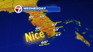
Wednesday’s weather will be similar. Look for afternoon highs warming into the lower and middle 80’s.
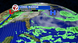
The next weather change will gradually evolve on Thursday. High pressure will weaken and slide away. In response, our local winds will turn out of the south. Most of the day should be dry but showers can’t be ruled out as moisture deepens (Thursday evening and night). You’ll probably detect the return of more humidity, too.
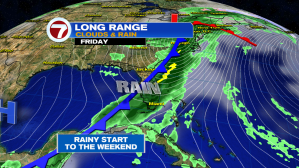
Finally, we’ll watch for an approaching front on Friday. The cold front will meet-up with the moisture and trigger times of rain with possible storms. If the front slows or lags, we’ll continue to get some showers into Saturday as well. The good news? Nice and dry conditions will return well before the start of Easter Sunday.