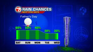
It’s been another active stretch of weather for south Florida. Strong thunderstorms still pop up, on a near daily basis. On Friday, the stormy weather came in a couple of doses… and featured gusty winds, for a short time. In Broward County, storm reports included wind gusts as high as 68 miles per hour near Deerfield Beach! Looking ahead, it’s a classic “squeeze play” in our weather pattern. As deep moisture continues to sit over the region, a weakening cold front is sagging southward into Florida. The combination of high humidity and instability (from the boundary) will likely lead to more scattered storms. The best chance for activity will be during the afternoon and evening hours. Also, of course, Father’s Day is nearly here. Most forecast maps still show the front lingering near south Florida (remaining intact) into Sunday. As a result, there’s still a good chance for rain with storms… possible at any point of the day on Sunday. The upcoming week features some slight improvement. As the front gradually dissipates, high pressure will rebuild from the Atlantic. Local winds will begin turning out of the east and the added breeze will be welcome too. While a few rain showers will still be possible, the coverage will be less. Also, any developing thunderstorms will tend to “drift away” (more inland) throughout the afternoon during the early part of the week.