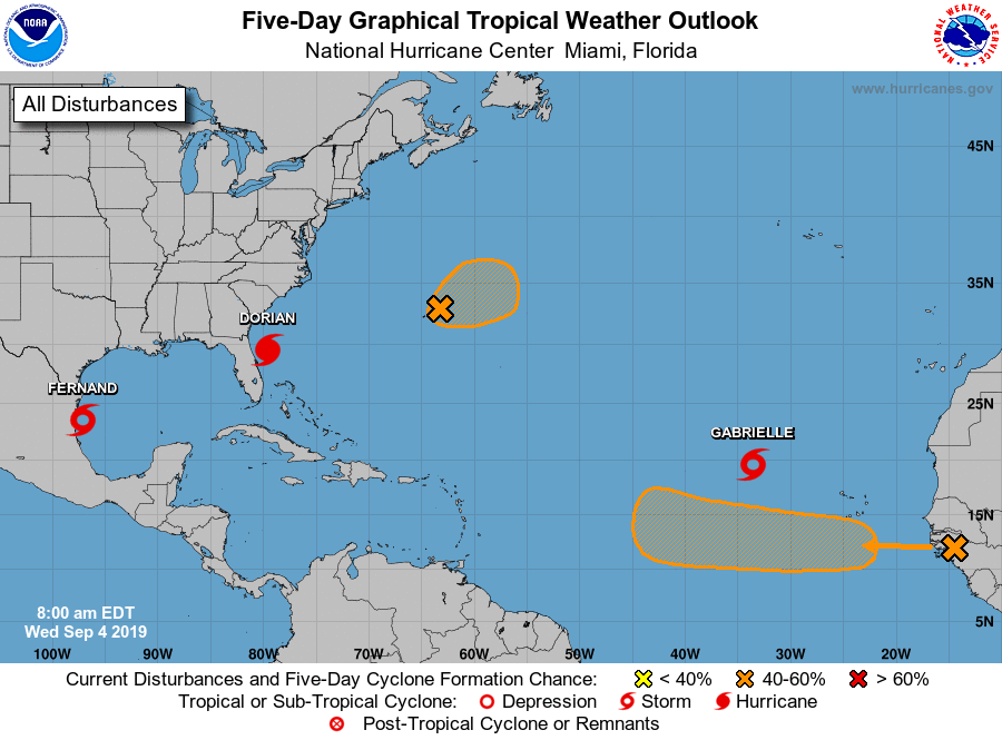
(WSVN) - The National Hurricane Center is monitoring two tropical waves and tracking three named storms in the Gulf of Mexico and Atlantic Ocean as hurricane season continues in its peak period.
Tropical Storm Fernand
Fernand formed Tuesday afternoon just off the coast of Mexico. As of 8 a.m., Wednesday, forecasters say it is tracking westward at 6 mph with maximum sustained winds of 50 mph. Tropical storm warnings are in effect from Puerto Altamira to the Mouth of the Rio Grande River.
Tropical Storm #Fernand is slowly moving West toward Northeastern #Mexico. Forecast to make landfall later today. @wsvn @7weather #flwx pic.twitter.com/8ltCbWXb9v
— Vivian Gonzalez (@VivianGonzalez7) September 4, 2019
Tropical Storm Gabrielle
Newly formed Gabrielle is forecast to move northwest across the open Atlantic waters, posing no threat to land. Current maximum sustained winds are 40 mph, as of the 5 a.m. advisory.
Depression strengthens into Tropical Storm #Gabrielle over the open Atlantic Ocean. Should remain no threat to land. @wsvn @7weather #flwx pic.twitter.com/kxWBmGkhVl
— Vivian Gonzalez (@VivianGonzalez7) September 4, 2019
Hurricane Dorian
Dorian is currently moving north-northwestward at 8 mph after stalling near Grand Bahama for around 15 hours earlier this week. As of the 8 a.m. intermediate advisory, it’s a category 2 storm with 105 mph maximum sustained winds. Coaster central and northern Florida are experiencing tropical storm force winds. Dorian will move along the southeastern coast, potentially affecting Georgia, South and North Carolina through end of the week.
5am advisory: Tropical storm conditions continue for the Northeastern Coast of #Florida. #Dorian remains a Cat 2 hurricane with max winds of 105 mph. @wsvn @7weather #flwx pic.twitter.com/3hBiq7BgQP
— Vivian Gonzalez (@VivianGonzalez7) September 4, 2019
Tropical waves
Two tropical waves are being monitored over the Atlantic and near the coast of Africa.
The first one, located just east of Bermuda, has a 50% chance of developing over the next 48 hours. NHC says a tropical depression could form over the next few days.
A second tropical wave is forecast to emerge off the coast of Africa. It currently has a near 0% chance forming through 48 hours. However, there’s a 60% chance of formation over the next 5 days as conditions become more conducive later this week.
Copyright 2024 Sunbeam Television Corp. All rights reserved. This material may not be published, broadcast, rewritten or redistributed.