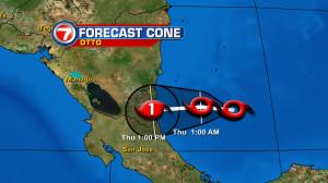
The holiday hustle is on and the weather isn’t going to slow you down. Across south Florida, pleasant temperatures are back. Lows are around 70 degrees (and not as cool as earlier in the week) while daytime readings warm up nicely. Expect consistency throughout the Thanksgiving time frame along with a mild ocean breeze. Wind speeds should subside by the weekend but rip currents are still a threat along Atlantic beaches, due to the onshore flow. If your holiday plans take you out of Florida there are a couple cold fronts spanning the national weather map. The first one is moving from the central states toward the eastern seaboard while causing travel headaches. It’s mainly a rain-maker (although some snow will fly across parts of New England, in time). This front will have difficulty “driving” southward. In fact, since the jet stream flattens out across our region, there’s not enough push to send it our way! What about the second cold front? It’s still far away and tracking out of the western states. Most of the forecast maps take it into Florida by Sunday with big time weakening. Regardless, our longer term temperatures won’t change much. The front may trigger a few raindrops during the upcoming weekend, but it’s not likely to bring anything significant or long lasting. Finally, and well removed from the United States, there’s a late season tropical system. Tropical Storm Otto will be moving into Central America this Thanksgiving holiday. Wild winds and flooding rains will be a concern from Nicaragua to Costa Rica, extending southward to Panama.