LOCAL:
The sea breeze will continue to fuel isolated showers along the coast through Memorial Day. With the heating of the day, expect spotty storms favoring the inland areas during the afternoon and evening hours. Also note: a slight risk of rip currents at local beaches with no boating advisories in place through Monday.
By Tuesday, drier air will move into South Florida. While we cannot rule out an isolated shower or two, we will see plenty of sunshine through the middle of the week.
More sun this #MemorialDayWeekend, expect few coastal showers & inland PM storms… drier WED #flwx @wsvn @7weather pic.twitter.com/rapBaUcabn
— Miss Chavis (@karlenechavis) May 29, 2016
Scattered showers and storms will return to the forecast by the end of the week.
TROPICS:
Bonnie is forecast to maintain Tropical Depression strength through Memorial Day over the inland areas along northeastern South Carolina.
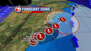
No Tropical Storm Warnings are in place due to this degrade.
2″ – 4″ inches of rainfall is expected with isolated maximum amounts of 8″ from east-central Georgia into central to eastern South Carolina. 1″ to 3″ farther north across southeastern North Carolina. Heavy rain is expected to develop well north of Bonnie’s main circulation into parts of the Mid-Atlantic and the Northeast with total accumulations of 1″ to 2″ through Monday and isolated maximum amounts of 4″.
Along with rainfall, Bonnie will produce dangerous surf and rip currents for the southeast coast.
Copyright 2024 Sunbeam Television Corp. All rights reserved. This material may not be published, broadcast, rewritten or redistributed.