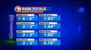
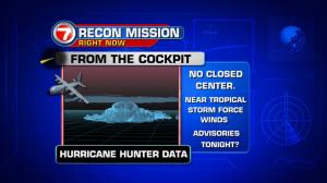
Batches of rain have been moving back over the area. On Tuesday, skies were murky with plenty of soaking downpours. Also, strong thunderstorms created gusty winds and a couple of waterspouts near the Florida Keys. The high winds over southeastern Broward County even toppled some trees in Davie. Most of the activity began gaining steam over southern areas… often impacting the Keys before reaching the south Florida mainland. It’s all been part of a steady push of deep moisture expanding over of the region (with as much as 6″ of rain near Homestead on Tuesday, alone). The wet and messy weather isn’t going to depart rapidly. However, there are signs that we’ll see “less coverage” of rain and storms into the middle of the week. In the meantime, typical sea breeze boundaries and broad low pressure will still trigger occasional showers. We’re also watching the tropics. A strong tropical wave is approaching the Windward Islands (in the Lesser Antilles). Recon planes have been conducting flight missions to get a better idea on its organization. It appears that a depression or storm will be classified within the next 24 hours. The system will spread into the eastern Caribbean, late Wednesday. As we get deeper into the week it’s going to be necessary to see when and where it turns. Long range forecast models are coming into focus that the tropical system will veer northward. Also, a relatively sharp turn is possible. It’s still too early to know the big answer: whether Florida or the east coast of the United States could be impacted, or not.


