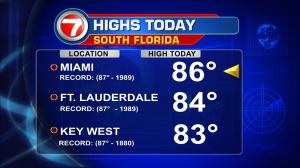
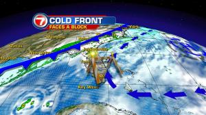
A cold front is entering Florida from the north, but it’s entry into south Florida is going to be a tall order, in the days ahead! The front happens to be the same one that’s been sending shivers across much of the nation. In many cases, temperatures have dropped 40 to 50 degrees with this sharp cold front! It’s now worked across the eastern half of the nation except for the tail end of it, which dangles over the panhandle. High pressure, over the Atlantic Ocean, isn’t going to retreat to allow the front to pass across the entire peninsula. From Monday through Tuesday, forecast maps show how the boundary struggles on a southward push. It may pass Orlando, but there’s little chance of it going beyond that location. Technically, it wouldn’t even matter much since the actual front weakens to nearly nothing. Does this mean we’re going to have more “extra warm” weather? The answer is yes, at least in the short run. Just like much of last week, temperatures will rise to near record levels. Both daytime and nighttime readings will run approximately 10-degrees above average. Once the Florida front dissipates, it will allow our winds to veer less out of the south and more out of the east. The result will be a small reduction in temperature and humidity by midweek. Then, another weak front should approach Florida. It could stir up a few rain showers (not a big deal) as it gets closer to us on Friday. Ultimately, we may see this (too) fizzle before the holiday weekend. At this point, there’s no real or detectable cooling in sight for the forecast period. If you have a lot of activities prior to Christmas, our south Florida weather pattern will basically cooperate in the days ahead.


