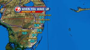
Back to back chilly nights and suddenly south Florida is feeling the coldest air in nearly a year. Several spots have been reporting low temperatures in the 40’s for the first time since last February. As you might guess, it’s “rare air” for folks who are used to feeling tropical conditions. This cold blast (frigid, by local standards) is from the powerful winter cold front that crossed on Saturday. Winds have primarily been from the north, and arriving in gusty fashion. The high wind speeds will last through Monday… before gradually subsiding. Throughout the first half of the week, though, more marine hazards are likely to continue. High seas and rough surf will make it dangerous for both swimming and boating. The current weather map shows a sprawling area of high pressure located north of Florida. The high will drift from the middle Atlantic states into the western ocean waters in the coming days. As that happens, we’ll disconnect from the chill and get a warmer dose of air. In turn, temperatures will return to seasonal levels by Wednesday with no more cold fronts in sight. There will be a chance for isolated rain showers moving ashore from the ocean (but any bit of wet weather won’t last long).