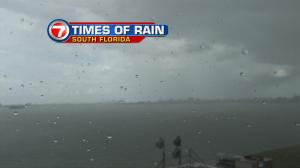
Showers and storms have been pushing across much of Florida. More of these “on and off” downpours will continue into the middle of the week (and probably beyond)! There’s plenty of tropical air still sitting over the region. It was basically left lingering here, trailing the former Tropical Storm Colin. Currently, there’s no organized activity in the tropics. That’s the good news. However, as moisture remains over us, it won’t take a lot to trigger more rain with storms. Activity will stay focused mainly over south and central Florida (while northern parts of the state get a break). The upper third of Florida is now tapping into drier air on the back side of a stationary front. That drying won’t be able to expand southward. With the front stuck nearby, it will lead to cloudy and humid weather for us. Winds should gradually decrease, too, which will make it feel even more steamy. Long range weather maps are hinting at the chance for at least some clearing for the upcoming weekend. Once our “Florida front” starts weakening and breaking apart (possibly by Saturday) the coverage of rain should come down. Daily storms will still be possible but they won’t be as numerous. As for temperatures, the heat will stay strong and remain summer-like.