WSVN — Getting ready for hurricanes means knowing what you need to do. Do you know if you are in an evacuation zone? Do you have what you need for your family and pets? How will you live if you lose power? We will answer all of these questions and more. We start with a warning from forecasters. Get ready now for any storms that form.
South Carolina was on the frontline of 2015’s first named storm. Tropical Storm Ana came ashore May 10, almost a full month before the official start of hurricane season.
Rick Knabb, National Hurricane Center: “They can hit us at any time, in any season.”
Even with the early arrival of Ana, experts are predicting a below average number of storms this year. But Knabb says, don’t get caught off guard.
Rick Knabb: “Look no further than South Florida during 1992. Hurricane Andrew, Category 5, made landfall in a below average year.”
Andrew packed winds of 155 miles per hour and a storm surge of 17 feet.
Daniel Brown, Senior Hurricane Specialist: “You can kind of hide from the wind when you live inland, but it’s hard to swim when storm surge rises and floods what is normally dry land.”
Storm surge is sea water rising and being pushed up over land by the winds of a tropical system. It can be a few inches deep or more than 30 feet, depending on the storm, and water can leave massive destruction in its wake. Hurricane Katrina’s storm surge was 27.8 feet at Pass Christian Mississippi. Superstorm Sandy’s surge, at 13 feet, flooded the New York City subway system, and washed out entire homes and a 50-foot section of the Atlantic City Boardwalk.
The National Hurricane Center is hoping several videos they have produced illustrate the dangers.
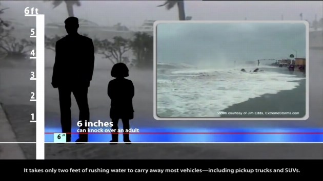
Tutorial: “A mere six inches of fast-moving water can knock over an adult.”
Two feet of extra water can move cars and trucks, and it’s important to know storm surge doesn’t just affect the coast. Storm surge waters can travel up rivers and through canals and flood inland areas. That’s why this year, for the first time, the Hurricane Center will be testing separate storm surge watches and warnings with graphics.
Daniel Brown: “It’s the first time the public can get a look and really see what the storm surge threat is.”
Using this map of the Tampa/St. Pete area, hurricane experts show us how they highlight and color code neighborhoods that could be hit by storm surge. The maps are color-coded to show how deep the water could get in your neighborhood.
Experts hope everyone will take their advice and prepare now so they are ready to evacuate if a storm threatens.
Rick Knabb: “If that one hurricane is on your doorstep, even though you didn’t think it was going to hit you this year because the numbers led you to believe otherwise and you haven’t prepared in advance, you’re really going to wish at that last moment that you had.”